post

Gallo-Romeins Museum Tongeren

In het midden van de 19de eeuw verzamelde het Koninklijk Geschied- en Oudheidkundig Genootschap van Tongeren archeologische vondsten. Met steun van het provinciebestuur voerde de vereniging ook opgravingen uit. Vanaf 1854 konden bezoekers de voorwerpen bekijken op diverse locaties in de stad. Tot in de eerste helft van de 20ste eeuw verwierf het Genootschap regelmatig nieuwe collecties. Vaak van privé personen die ook opgravingen uitvoerden. In 1937 verhuisde de verzameling naar het nieuw opgerichte Provinciaal Museum in het Begijnhof van Hasselt.

In 1954 startte het eerste echt volwaardige museale initiatief. De belangrijkste archeologische vondsten uit de regio werden verzameld en getoond in het Provinciaal Gallo-Romeins Museum in Tongeren. De collectie breidde zich alsmaar verder uit. Onder andere dankzij opgravingen van de toenmalige ‘Nationale Dienst voor Opgravingen’, de archeologische buitendienst van het museum zelf en de vele schenkingen. Het museum toonde de objecten op een klassieke manier. Soms organiseerde het ook tijdelijke tentoonstellingen. Het aantal bezoekers nam toe, tot 20.000 per jaar. Voor vele scholen groeide het museum uit tot een vaste waarde.

Begin jaren 1990 besliste de bestendige deputatie om te investeren in een nieuw museumgebouw en een vernieuwende museale aanpak. In 1994 opende het museum ‘nieuwe stijl’. De eigentijdse presentatie van de collectie, de onderbouwde educatieve werking en het laagdrempelige tentoonstellingsbeleid verhoogden de aantrekkingskracht. De collectie werd systematisch aangevuld. Denk maar aan het bronzen bijlendepot van Heppeneert, het Keltisch gouddepot met halsring van Beringen en de ‘muntschat van Ambiorix’, gouden munten van onder meer de Eburonen.

Vrij snel werd het nieuwe museum slachtoffer van zijn eigen succes. Bijna 150.000 mensen bezochten de tentoonstelling ‘Neanderthalers in Europa’ (2004-2005). De tentoonstellingsruimtes en educatieve ruimtes waren ongeschikt om deze toevloed kwaliteitsvol op te vangen. In 2000 zette de bestendige deputatie het licht op groen voor een nieuwe uitbreiding. In 2004 was de financiering voor de nieuwbouw rond en in 2006 werd het bouwdossier opgestart. Het museum kreeg hiermee alle kansen om door te groeien tot één van de belangrijkste archeologische musea van Europa.

Thermenmuseum Heerlen

Het Thermenmuseum is een oudheidkundig museum in het centrum van de Nederlands-Limburgse stad Heerlen. Het museum is geopend in 1977 en is gebouwd rond de opgraving van een Romeins badhuis, het grootste en best bewaarde antieke gebouw in Nederland.In 1940 werd in het centrum van Heerlen het fundament ontdekt van een thermencomplex, het tot nu toe belangrijkste bouwwerk van de Romeinse nederzetting Coriovallum. Een boer die het braakliggende grasland aan het omploegen was bleef op 18 juni van dat jaar met zijn ploeg in een deel van zuilschacht steken. Later werden nog drie zuilfragmenten gevonden. Een aantal dagen later begon amateurarcheoloog dr. H.J. Beckers, geholpen door vrijwilligers, met een grote opgraving en in 1941 waren de voor Nederland imposante archeologische resten blootgelegd.

Het badhuis is in twee fasen gebouwd was: de eerste fase uit de eerste eeuw na Christus en enkele decennia later een uitbreiding en verbouwing omstreeks het jaar 40 na Chr.  Het bestond uit een ommuurd terrein met daarbinnen een badgebouw van 50 bij 50 meter. Via een overdekte zuilengalerij kwam men achtereenvolgens in een kleedruimte (apodyterium), een zweetruimte (sudatorium), twee dompelbaden (frigidaria), een verwarmde massageruimte (tepidarium) en een warmwaterbad (caldarium). Indrukwekkend zijn de restanten van het hypocaustum (vloerverwarmingssysteem). Ook is een fragment van een mozaïekvloer in één van de frigidaria bewaard gebleven. Buiten was er nog een openluchtbad (natatio), kon er gesport worden in een speciaal daarvoor aangelegde ruimte (palaestra), en waren er toiletten en kleine winkeltjes.

Rijksmuseum van Oudheden Leiden

Het museum beheert collecties van archeologische artefacten afkomstig uit culturen die van grote invloed zijn geweest op onze hedendaagse cultuur. Daarnaast beheert het museum ook de topstukken van de Nederlandse archeologie daterend van de prehistorie tot aan het einde van de middeleeuwen. De collectie is verdeeld over een aantal afdelingen, een indeling die is doorgevoerd in de vaste tentoonstelling.

Het museum beheert collecties van archeologische artefacten afkomstig uit culturen die van grote invloed zijn geweest op onze hedendaagse cultuur. Daarnaast beheert het museum ook de topstukken van de Nederlandse archeologie daterend van de prehistorie tot aan het einde van de middeleeuwen. De collectie is verdeeld over een aantal afdelingen, een indeling die is doorgevoerd in de vaste tentoonstelling.

Romervilla Bad Neuenahr

Die Römervilla von Bad Neuenahr-Ahrweiler am Silberberg ist ein archäologischer Fundplatz, der eine jahrhundertelange wechselnde Nutzung von der Mitte des ersten nachchristlichen Jahrhunderts bis ins Frühmittelalter dokumentiert. Das ergrabene Areal befindet sich am Rand der rheinland-pfälzischen Stadt Bad Neuenahr-Ahrweiler im Landkreis Ahrweiler.

Verfall und der Bedeckung des Geländes mit Schutt und Geröll durch den direkt dahinterliegenden Silberberg entstand an diesem Platz ein frühmittelalterlicher christlicher Friedhof. Die besondere Bedeutung des ergrabenen und für die Öffentlichkeit konservierten Hauptgebäudes liegt in dem hervorragenden Erhaltungszustand vieler seltener Baudetails und Wandmalereien.

Villa Otrang

The well-preserved remains of the manor house of a Roman farming estate are located 5 km (3 mi) north of the former Roman way station Beda Vicus (the present-day county seat Bitburg) .

The Biedermeier buildings covering the Roman remains have stood since the excavations of 1836 and are now under monument protection. Of the rich furnishings, the bath and the heating system and the mosaic floors found in the villa have been preserved.

Villa Nennig

Located in Perl-Nennig south of Trier, this gladiatorial mosaic is one of the most important Roman artifacts north of the Alps. It graced the entrance or reception hall (atrium) of a palatial villa which, like those praised by Ausonius, was situated on a slope of the Mosel valley. The elaborate pattern of geometrical designs is comprised of seven octagonal medallions surrounding two central quadrangles, one decorated with a scene of gladiatorial combat, the other occupied by a marble basin at the original entrance to the hall.
post

Pont du Gard

The Pont du Gard is an ancient Roman aqueduct that crosses the River Gardon in the south of France. Located near the town of Vers-Pont-du-Gard, the bridge is part of the Nîmes aqueduct, a 50-kilometer system built in the first century AD to carry water from a spring at Uzès to the Roman colony of Nemausus (Nîmes). Because of the uneven terrain between the two points, the mostly underground aqueduct followed a long, winding route that called for a bridge across the gorge of the Gardon. The Pont du Gard is the highest of all elevated Roman aqueducts, and, along with the Aqueduct of Segovia, one of the best preserved. It was added to UNESCO’s list of World Heritage Sites in 1985 because of its historical importance.   The bridge has three tiers of arches, standing 48.8 m (160 ft) high. The whole aqueduct descends in height by only 17 m (56 ft) over its entire length, while the bridge descends by a mere 2.5 cm (0.98 in) – a gradient of only 1 in 3,000 – which is indicative of the great precision that Roman engineers were able to achieve, using only simple technology. The aqueduct formerly carried an estimated 200,000 m3 (44,000,000 imp gal) of water a day to the fountains, baths and homes of the citizens of Nîmes. It continued to be used possibly until the 6th century, with some parts used for significantly longer, but lack of maintenance after the 4th century meant that it became increasingly clogged by mineral deposits and debris that eventually choked off the flow of water. After the collapse of the Roman Empire and the aqueduct’s fall into disuse, the Pont du Gard remained largely intact, due to the importance of its secondary function, as a toll bridge. For centuries the local lords and bishops were responsible for its upkeep, in exchange for the right to levy tolls on travellers using it to cross the river, although some of its stones were looted and serious damage was inflicted on it in the 17th century. It attracted increasing attention starting in the 18th century and became an important tourist destination. It underwent a series of renovations between the 18th and 21st centuries, commissioned by the local authorities and the French state, that culminated in 2000 with the opening of a new visitor centre and the removal of traffic and buildings from the bridge and the area immediately around it. Today it is one of France’s most popular tourist attractions and has attracted the attention of a succession of literary and artistic visitors.
Visit July 1975. Praktika XL SLR, Agfa photo slides. Visit June 2017 Canon 70D, 100D

Arles Arelate Amfitheatre

The Arles Amphitheatre  is a Roman amphitheatre in the southern French town of Arles. This two-tiered Roman amphitheatre thrived in Roman times. The pronounced towers jutting out from the top are medieval add-ons. Built in 90 AD, the amphitheatre was capable of seating over 20,000 spectators, and was built to provide entertainment in the form of chariot races and bloody hand-to-hand battles. Today, it draws large crowds for bullfighting during the Feria d’Arles as well as plays and concerts in summer.
Visit June 2017.  July 1975 Praktika XL SLR, Agfa slide.

Tropaeum Alpium, La Turbie

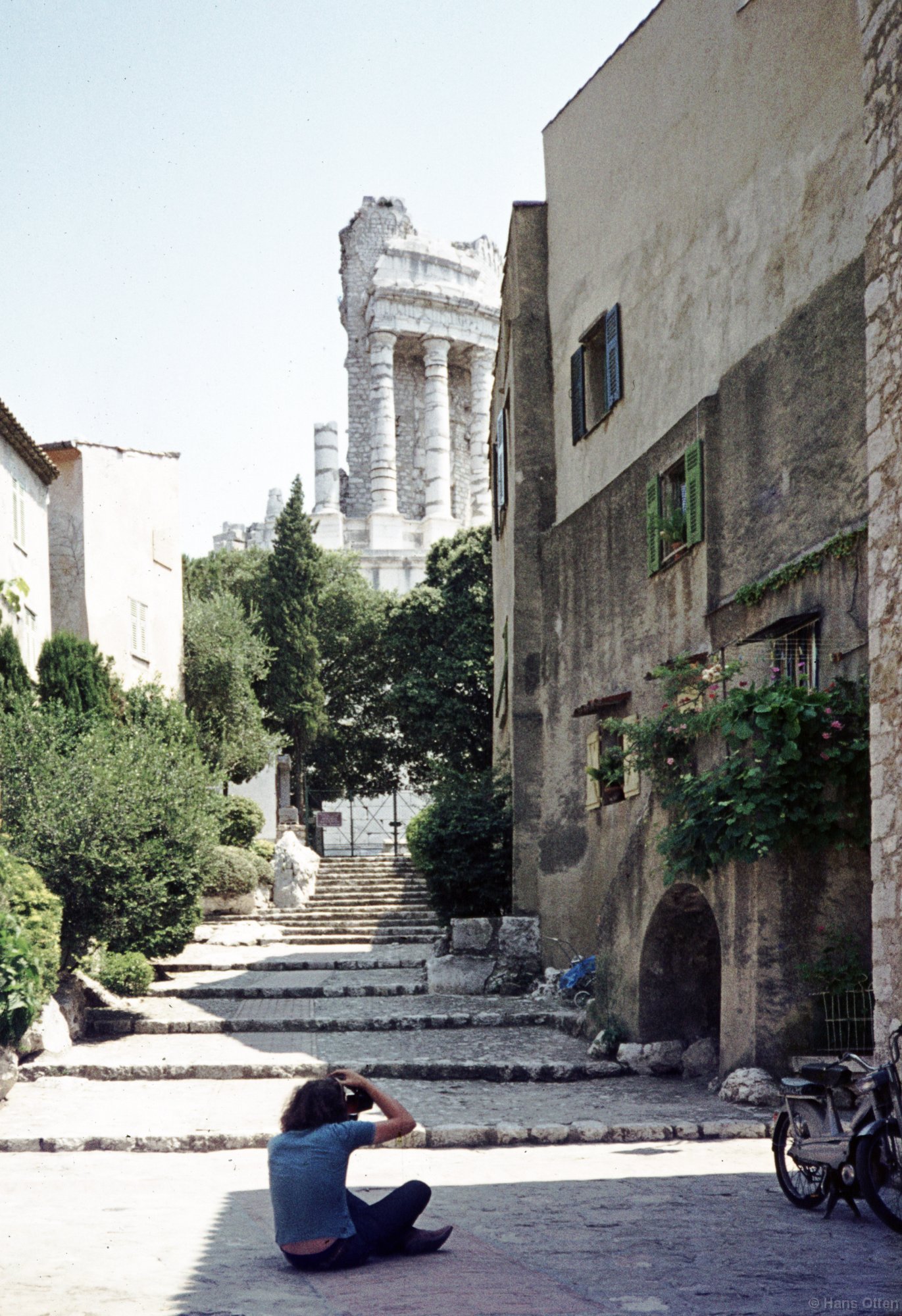
The Tropaeum Alpium (Latin for “Victory Monument of the Alps”, French: Trophée des Alpes), was built by the Romans for the emperor Augustus to celebrate his definitive victory over the ancient tribes who populated the Alps. The monument’s remains are in the commune of La Turbie (France), a few kilometers from the Principality of Monaco (Latin: tropaeum from Greek: tropaion whence English: “trophy”). The Trophy was built c. 6 BC in honor of the emperor Augustus to celebrate his definitive victory over the 45 ancient tribes who populated the Alps. The Alpine populations were defeated during the military campaign to subdue the Alps conducted by the Romans between 16 and 7 BC. The stone used to build the monument was originally extracted from the Roman quarry located about 500 metres away. Visitors to that site can still see the traces of sections of carved columns in the stone.

On the next photograph you see me sitting on the pavement shooting the photo above. Visit July 1975. Praktika XL SLR, Agfa slides.

Hadrian’s Wall Fort Birdoswald

Birdoswald was a major Roman military fort built to protect Hadrian’s Wall and a crossing of the River Irthing.
Birdoswald’s history began when a wooded spur was cleared for the building of Hadrian’s Wall in AD 122. The fort, added to the Wall shortly afterwards, was garrisoned by an infantry cohort of more than 800 men and remained in occupation throughout the Roman period. Outside the fort an extensive settlement (vicus) grew up.

Archaeological investigation has shown that the garrison continued to be occupied into the 5th century – the so-called ‘Dark Ages’. The fort was reoccupied in the Middle Ages and was the target of raids by border reivers in the 16th century. First excavated in the 1850s, Birdoswald has produced more evidence for the phases of building of Hadrian’s Wall than any other fort.

Building the wall and the fort

To the west of the river Irthing Hadrian’s Wall was at first built of turf. In this sector the regular fortlets known as milecastles were built of turf and timber, while the turrets between them were of stone. At Birdoswald the builders of the turf Wall had to clear woodland and drain a small bog before construction could start. A ditched and palisaded camp for the builders is the earliest evidence for occupation on the site, and pieces of leather tent were found in its ditches. The fort was built astride the Wall, which, along with one of the stone turrets, was partially demolished to accommodate it. The fort may have begun as a turf and timber construction, but this phase was not completed and a stone fort was begun instead. At 2.14 hectares it was one of the larger forts on Hadrian’s Wall. Work apparently stopped for a period of years at one point, but construction was completed before the end of the reign of Hadrian (AD 138) and most of the internal buildings date from this time. After the fort walls were finished, the first five miles of turf Wall were rebuilt in stone. We do not know what unit garrisoned Birdoswald under Hadrian, but it would have been an auxiliary unit raised from one of the peoples conquered by Rome. The fort had been completed and a settlement had begun to develop outside the walls when Hadrian’s successor, Antoninus Pius (r. AD 138–61), moved the army north.
After the Antonine interlude Birdoswald was fully occupied, probably by the military unit that remained there throughout the 3rd and 4th centuries. This was cohors Prima Aelia Dacorum (the first cohort of Dacians, Hadrian’s own, 1,000 strong unit), recruited from what is now Romania. The typical curved sword of the Dacians (falx) is depicted together with a palm frond as badges on two of their building inscriptions. One of these commemorates the building of a granary in AD 205–8 in collaboration with a Thracian cohort and under the command of the tribune Aurelius Julianus. During his time at Birdoswald Julianus lost his infant son, Aurelius Concordius, who was commemorated on a tombstone at the fort cemetery.The second inscription (above) records building work at the main east gate in AD 219. The cohort is recorded in a series of 23 altars to Jupiter Optimus Maximus, five other religious inscriptions, one tombstone and one building stone. The examples that can be dated span the entire 3rd century, after which the habit of making inscriptions on stone declined across the whole frontier.other wall (the Antonine Wall) from the Forth to the Clyde. Birdoswald was certainly not given up during the brief occupation of this wall (about AD 142–60), but may have been held by a reduced ‘caretaker’ garrison.

During the 3rd century repairs and rebuilding took place within the fort. Outside the walled fort the civilian settlement (vicus), which was made up of buildings with stone foundations set along streets, grew to the east and west and even to the north. South of the fort timber buildings and a type of pottery associated with Frisia, in north-western Europe, show the presence of an irregular military unit which adhered to its traditional lifestyle. Whether this was the unit named the Venatores Bannienses, or ‘Hunters of Banna’, as recorded on an altar found at the fort, is not known. The fort may have been briefly abandoned in the late 3rd century, to judge from the last Birdoswald inscription, which records the rebuilding of the commander’s house that had ‘been covered in earth and fallen into ruin’. The Dacian unit, however, seems to have remained there until the end of the 4th century, when it is recorded in the Notitia Dignitatum, a list of military and civil service posts across the empire.

Post-Roman period

One of the most important recent discoveries on Hadrian’s Wall has been that some forts continued to be occupied beyond the ‘end of Roman Britain’ in the early 5th century. Some of the best evidence for this comes from Birdoswald where, on the site of the Roman granaries, a series of hall-type buildings was found. At first these reused the southern granary but later, when this became unviable, two phases of free-standing wooden buildings were erected. It is clear that this occupation continued without a break from the late Roman period, marking a radical change in the life of the fort after the collapse of the Roman administration and economy. The Roman military unit, already subject to late Roman local recruitment and hereditary service, perhaps became more akin to a war band, possibly even a small local chiefdom, whose members would have continued to regard themselves as ‘Roman’